Maritime communication and navigation, commonly referred to as "船舶通导" in Chinese, encompass the integrated systems and technologies essential for safe, efficient, and reliable vessel operations at sea. These systems serve as the "eyes and ears" of ships, enabling real-time data exchange, precise positioning, collision avoidance, and coordination with shore-based authorities. Given the vast and often hazardous marine environment, the robustness of maritime communication and navigation systems is critical to preventing accidents, optimizing routes, and ensuring compliance with international regulations. This article explores the core components, technological advancements, challenges, and future trends in maritime communication and navigation, highlighting their indispensable role in modern shipping.
Core Components of Maritime Communication and Navigation Systems
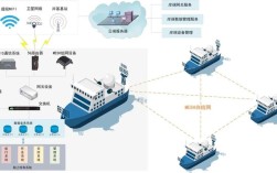
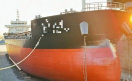
Maritime communication and navigation systems are broadly categorized into two interconnected domains: navigation systems (for positioning and route guidance) and communication systems (for data exchange and coordination).

Navigation Systems
Navigation systems are designed to determine a vessel’s position, monitor its movement, and ensure it stays on course. Key technologies include:
- Global Navigation Satellite Systems (GNSS): GNSS, such as GPS (U.S.), GLONASS (Russia), Galileo (EU), and BeiDou (China), provide global coverage with high-precision positioning (up to centimeter-level accuracy with differential corrections). These systems are fundamental for route planning, anchoring, and harbor entry.
- Radar and Automatic Identification System (AIS): Marine radar detects nearby vessels and obstacles, while AIS automatically transmits and receives vessel data (e.g., position, speed, course) to prevent collisions. Class A AIS is mandatory for commercial vessels, while Class B is used for smaller crafts.
- Electronic Chart Display and Information System (ECDIS): ECDIS digitizes nautical charts, integrating real-time data from GNSS, radar, and AIS to provide a comprehensive navigational overview. It complies with the International Maritime Organization (IMO) SOLAS Convention as a primary navigation tool.
- Echo Sounder and Gyrocompass: Echo sounders measure water depth to avoid grounding, while gyrocompasses provide accurate heading references, independent of magnetic interference.
Communication Systems
Communication systems facilitate voice and data exchange between vessels, satellites, and shore stations. Key technologies include:
- Very High Frequency (VHF) and Maritime Mobile Satellite Service (MMSS): VHF radio is used for short-range communication (e.g., ship-to-ship or ship-to-shore), while MMSS (e.g., Inmarsat, Iridium) enables global coverage for distress calls, email, and weather updates.
- Automatic Identification System (AIS) for Communication: Beyond navigation, AIS transmits vessel data to shore-based authorities for traffic management and search-and-rescue operations.
- Long-Range Identification and Tracking (LRIT): Mandatory for SOLAS vessels, LRIT transmits position data to flag states and coastal authorities to enhance maritime security.
- Digital Selective Calling (DSC): DSC enables automated distress alerts, ensuring rapid response during emergencies.
Technological Advancements and Integration
Recent innovations have significantly enhanced the capabilities of maritime communication and navigation systems. The shift from analog to digital technologies has improved data accuracy, reliability, and integration. For example, ECDIS now supports real-time weather routing, dynamic updates, and collision avoidance algorithms, reducing human error.
Satellite communications have evolved from low-bandwidth voice services to high-speed broadband (e.g., VSAT), enabling crew welfare services (e.g., internet access, video calls) and operational efficiency (e.g., remote monitoring of machinery). Additionally, the adoption of e-Navigation—an IMO-led initiative—aims to integrate all navigational and communication systems into a unified platform, enhancing situational awareness and reducing workload for mariners.

Artificial intelligence (AI) and machine learning are also being leveraged for predictive analytics, such as forecasting weather hazards, optimizing fuel consumption, and automating collision avoidance. Autonomous vessels, though still in development, rely heavily on advanced GNSS, radar, and communication systems to operate without human intervention.
Challenges and Mitigation Strategies
Despite advancements, maritime communication and navigation systems face several challenges:
- Cybersecurity Risks: As systems become more interconnected, they are vulnerable to cyberattacks (e.g., hacking, data breaches). Mitigation measures include regular software updates, encryption, and crew training on cyber hygiene.
- Signal Interference and Reliability: GNSS signals can be jammed or spoofed in conflict zones or congested waters. Redundant systems (e.g., integrating multiple GNSS and inertial navigation systems) ensure continuous operation.
- High Costs: Deploying and maintaining advanced systems (e.g., VSAT, ECDIS) can be expensive, particularly for small-scale operators. Modular and cost-effective solutions are being developed to address this.
- Human Factors: Over-reliance on automation may lead to complacency. Regular training and simulation exercises are essential to ensure mariners can manually operate systems during failures.
Future Trends
The future of maritime communication and navigation is poised for transformative changes:
- Autonomous Shipping: Fully autonomous vessels will rely on AI, 5G, and high-precision GNSS for navigation, with remote monitoring from shore.
- Satellite-Based Augmentation Systems (SBAS): Systems like WAAS (U.S.) and EGNOS (EU) enhance GNSS accuracy, supporting safer navigation in challenging conditions.
- Sustainable Technologies: Energy-efficient communication and navigation systems, such as low-power satellite sensors, will align with the maritime industry’s decarbonization goals.
- Enhanced e-Navigation: Further integration of AI, big data, and IoT will create a seamless "smart maritime" ecosystem, improving safety and efficiency.
FAQs
Q1: What is the difference between Class A and Class B AIS?
A: Class A AIS is mandatory for commercial vessels (e.g., passenger ships, tankers) and transmits data every 2–10 seconds, with higher power output and more detailed information (e.g., static voyage data). Class B AIS is used for smaller vessels (e.g., fishing boats, yachts) and transmits data every 30 seconds, with reduced functionality and lower power output. Class B AIS is not mandatory but recommended for collision avoidance.

Q2: How do maritime communication systems ensure reliability in remote areas?
A: Maritime communication systems use a combination of technologies to ensure reliability in remote areas. For instance, MMSS (e.g., Inmarsat) provides global coverage via satellites, while VHF radio is used for short-range communication in coastal zones. Redundant systems, such as carrying both satellite and VHF equipment, and emergency beacons (e.g., EPIRB), further enhance reliability by ensuring backup communication during distress situations.